Category
Scan converting a point refers to the process of determining which pixel on a raster display should be illuminated or assigned specific attributes to represent the given point. Since a point has no spatial extent, scan converting a point involves choosing a single pixel location to represent it.
The process of scan converting a point is relatively straightforward. The coordinates of the point are usually given in terms of the x and y positions on the display. The pixel corresponding to the nearest integer values of the point's coordinates is typically selected to represent the point. In some cases, rounding or other interpolation methods may be used to determine the pixel location more accurately.
Once the pixel location is determined, it can be illuminated with a specific color or attribute to represent the point visually. This involves setting the pixel's color value or other properties according to the desired representation.
Example: Display coordinates points 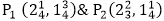 as shown in Fig would both be represented by pixel (2, 1). In general, a point p (x, y) is represented by the integer part of x & the integer part of y that is pixels [(INT (x), INT (y).

In summary, scan converting a point involves choosing the nearest pixel location and assigning it the appropriate attributes to represent the given point on a raster display.